03 Feb Montana’s Sun River
I can’t believe all that water tore through here,” I reflected. “Even Noah’s proverbial ark would have splintered on the rocks, the world’s animals lost.” My wife Mary and I gaped over a rocky precipice into the maw of western Montana’s Sun River Canyon, time-traveling back to an epic deluge of biblical proportions. The roar of raging water through the glacially carved abyss might have instilled fear of a vengeful Old Testament god in the few beleaguered souls witnessing the torrent: car-sized boulders cascading along the riverbed, giant logs bouncing like mosh-pit punk dancers on the surface, seemingly impregnable banks dissolving into swirling, chocolate-colored currents.
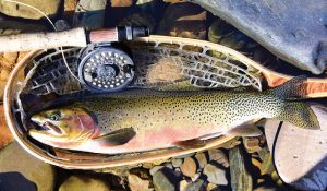
Native westslope cutthroat trout still patrol the upper Sun River watershed — just as they did when Lewis and Clark passed through — along with browns, brookies, and rainbows.
This scene was created by the perfect apocalyptic storm on June 7 and 8, 1964, as torrential rains fell at the rate of an inch per hour — up to 16 inches — quickly melting the deep, lingering snowpack in the Northern Rockies and unleashing Montana’s most destructive flood in history. Thirty-one people perished — all but one on the Blackfeet Reservation near Browning — and 8,700 were evacuated, while massive property and resource damage was left in its wake. Families were plucked from roofs by military helicopters, as houses, barns, dams, trucks, highways, and bridges were swept downstream and eventually scattered across the landscape like haunted ruins.
The Rocky Mountain Front’s Sun River was the epicenter of the flood, where rapidly rising water thundered over Gibson Dam for 20 hours — at a rate of approximately 50,000 cubic feet of water per second — flooding every valley community 70 miles downstream to Great Falls and the Missouri River. Unlike other dams that were washed away — unleashing deadly tsunamis — Gibson held, preventing an even bigger cataclysm. But the Sun’s stream channel, floodplain, and fisheries were profoundly altered, leaving even the most flood-savvy trout stranded in muddy pastures.
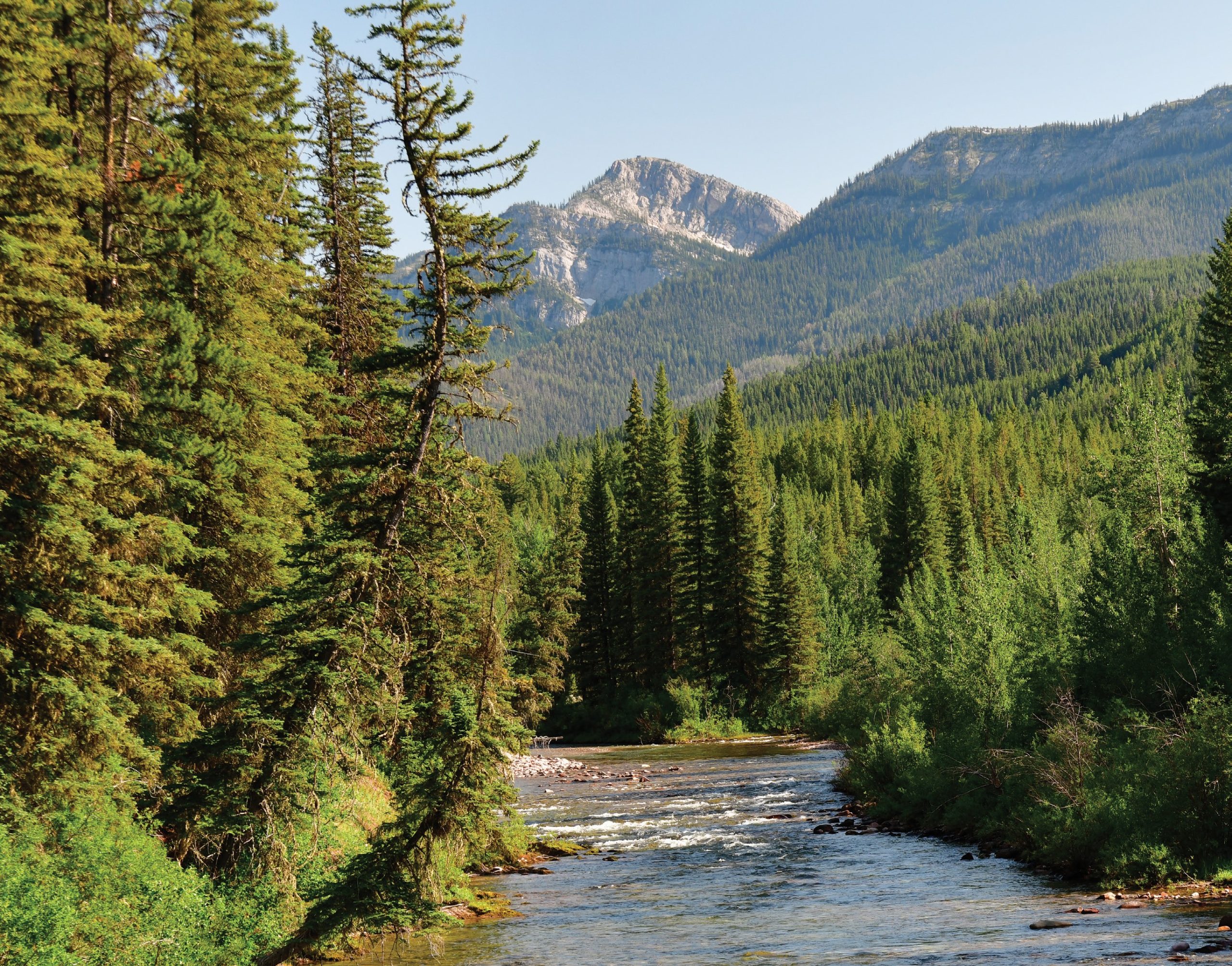
Framed by the Sawtooth Range, this stunning run lies on the main Sun River near Home Gulch Campground.
Time often heals, sometimes slowly, as it did on the severely wounded Sun River. And while modest floods often improve fisheries — adding nutrients and creating new habitats, such as log jams, deep pools, and rubble-filled runs — a maelstrom like the flood of 1964 can inflict long-lasting damage. Though still environmentally challenged, the Sun is now — 58 years later — in better shape, no longer instilling dread, but rather inviting anglers and trout alike to enjoy its waters.
Diverse Fisheries & Multifaceted Geography
When the Lewis and Clark expedition first camped near the mouth of the Sun River on the westbound journey in 1805, the men reportedly finished their treasured liquor supply and danced to fiddle music, celebrating Independence Day. Incidentally, on this stopover, Meriwether Lewis was chased into the Missouri River by an irascible grizzly bear — having forgotten to reload his gun after shooting a bison, and with nowhere to hide “from this monster.” After Lewis desperately brandished his spear-like “espontoon,” the enraged beast whirled and retreated toward the Sun River. A year later, on the return trip, Lewis and a contingent of men revisited the Sun, and near the mouth, he reported: “10 thousand buffaloe [sic] within a circle of 2 miles,” adding, “our horses had not being acquainted with the buffaloe they appeared much allarmed [sic] at their appearance and bellowing.”
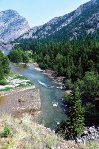
Below Gibson Reservoir, the Sun River races through a constricted limestone canyon, creating fine water for fly anglers who are up for a scramble. During the epic 1964 flood, a deluge thundered through the gorge.
Back then, the Sun River was teeming with indigenous westslope cutthroat trout and iridescent arctic grayling. While today, cutts still thrive in the headwaters, the river also holds non-native brook, brown, and rainbow trout, while watershed reservoirs like Nilan, Pishkun, and Willow Creek variously offer trout, kokanee salmon, and warm water species like perch and snaggle-toothed northern pike. There’s something for casters of all stripes.
This sprawling watershed remains off the heavy-rotation fly-fishing playlist that includes rock stars like the Madison, Missouri, Yellowstone, Bighorn, and Big Hole rivers with their drift-boat armadas. Set amidst some of Montana’s most jaw-dropping, national park-caliber scenery, the Sun drainage is a hydra-headed maze that, while difficult to readily conceptualize, is an escape that invites deep exploration.
Above Gibson Reservoir, the Sun fractures into the North and South Forks amidst peaks soaring beyond 8,000 feet, and is fed by summer snowfields and accessed by wilderness trails. For trout anglers hoisting packs or saddling horses, pristine headwaters beckon along both branches, with mazes of tributaries and alpine tarns. After rushing through a spectacular gorge below Gibson, the Sun threads through a productive agricultural valley with very fishable trout water. And below the mouth of Muddy Creek, the tepid, turbid lower Sun leisurely hits the Missouri River just west of Great Falls, where sizable pike can be found.
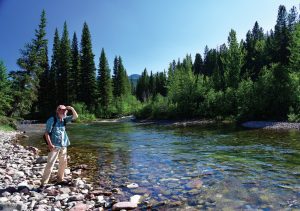
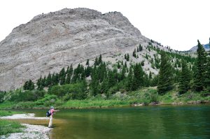
The crystalline water of the upper Sun lends itself to sight fishing; but keep a sharp eye out for grizzly bears.
Along the Sun, there are multiple opportunities for those anglers who are not looking for a serious backcountry adventure. For remote, rustic comfort, the K Bar L Ranch can be accessed by foot, horse, or boat (if Gibson Reservoir is high enough). Located at the trout-rich Forks Junction near the Bob Marshall Wilderness, the ranch offers fishing, hiking, hunting, pack trips, and therapeutic soaks in the 86-degree mineral water at Medicine Springs. Downstream, a network of national forest campgrounds affords excellent access, including South Fork/Benchmark, Mortimer Gulch, Home Gulch, and Wood Lake, which is a beautiful body of water that feeds a major tributary of the Sun. Further down, amidst sprawling farms and ranches, are river and reservoir public access points managed by Montana Fish, Wildlife & Parks, some of which offer camping. Also, the Bureau of Land Management’s Lowry Bridge site, west of Simms, features cottonwood-fringed campsites, a boat launch, and wading access to enticing water.
Routes, Dams, Diversions, & Water Challenges
The Sun River Valley’s rich resources have long attracted different cultures, including the Blackfeet, who hunted bison in the rolling grasslands, sometimes running them over “pishkuns,” or cliff-like jumps. They referred to the stream as the “Medicine River,” allegedly due to healing bankside minerals. The ancient Native American Old North Trail crosses the Sun, too, paralleling the dramatic thrusts, folds, and uplifts of the Rocky Mountain Front. The path, winding from Canada to Mexico, was an important thoroughfare for millennia; though much has faded, traces remain, strewn with artifacts. As Pulitzer Prize-winning Montana novelist A.B. Guthrie observed, “History runs into mystery here.”
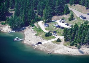
The Mortimer Gulch Recreation Site at Gibson Reservoir features a boat launch, campground, and a trailhead that leads into the Bob Marshall Wilderness. Gibson Dam and the Sun River irrigation project profoundly altered the lower Sun, but it remains a beguiling, off-beat destination for anglers.
In 1860, change accelerated in the valley when the 624-mile Mullan Road — the first engineered thoroughfare in the Northern Rockies — was completed between Fort Benton, Montana and Walla Walla, Washington. Supplies shipped by Missouri River steamboats were laboriously transported overland by wagons (and sometimes even camels!) to burgeoning mining towns like Helena and other points west. The road followed the lower Sun River for 12 miles and jumpstarted Euro-American settlements, which were opened to homesteading in 1862 and among the first communities in the valley.
The Mullan Road’s crossing of the Sun River was strategic, and the U.S. military built Fort Shaw about 5 miles upstream in 1867 to protect the corridor. The fort quickly became a focal point for early dry-land homesteaders migrating to the valley. Today, remnant buildings endure, and the site is on the National Register of Historic Places.
Transformation continued when the 199-foot-high, federally-sponsored Gibson Dam was completed in 1929. Christened after the founder of Great Falls, Paris Gibson, the structure was integral to one of Montana’s most complex and important irrigation systems, the Sun River Project. The project was pushed by Great Falls businessmen (and Minnesota Great Northern Railway magnate James J. Hill) who envisioned their town as a “new Minneapolis,” collecting, processing, and shipping Sun River agricultural products. Bolstered by a network of canals, ditches, and storage reservoirs, the system eventually delivered water to more than 100,000 acres of croplands around the Sun Valley and Greenfields Bench near Fairfield, becoming an important regional economic cog, supporting large-scale production of malt barley for beer, among other commodities.
Today’s challenge in the valley is maintaining both a reliable irrigation supply and a stable flow of cold, clean water in the lower river to support the fishery. During hot, dry weather, the depleted lower Sun is often subject to angling restrictions to protect trout that are stressed from low flows and water temperatures pushing toward a lethal 80 degrees. For anglers, the obvious solution is to head upstream, to colder, higher elevation reaches.
According to state fisheries biologist Jason Mullen, counts in the upper forks average a healthy 600 trout per mile. Conversely, 2021 surveys downstream found 183 trout per mile near Augusta, 168 at Simms, and only 85 at the town of Sun River. Mullen said the Sun “is probably fully recovered from the 1964 flood,” but other factors inhibit the lower fishery.
Larry Dolan, a retired state hydrologist who volunteers with the Sun River Watershed Group, is well-schooled in working with disparate interests toward collaborative solutions, improving drainages project by project. Dolan explains that, during the irrigation season, 90 percent of the Sun’s flow can be diverted into the Pishkun Canal, located several miles below Gibson, which can handle a voluminous 1,400 cubic feet per second. “It’s a heavily regulated system, with a high irrigation demand,” says Dolan, explaining that existing water rights “could dry up the river legally.” So the challenge is getting everyone together cooperatively: trusting, talking, listening, adjusting, and trying to satisfy diverse demands. Dolan says the lower Sun is ultimately “a working river,” but “the potential is there for a great fishery.”
Where to Hang Your Stetson
When Mary and I pulled into the Log Gulch Campground, we found an idyllic Sun-side spot; the previous guests’ kids had left creative, hand-painted rocks for us, a good omen. Castle Reef and the Sawtooth Range reared above, slicing the sky and sheltering prehistoric marine fossils entombed in limestone. Mary scanned the cliffs with binoculars for mountain goats and bighorn sheep. Later, we sipped velvety rum around the campfire, admiring the disco ball stars that illuminated the valley and canyon walls. The next day, we found an excellent stretch of the Sun that afforded room to roam the shoreline cobbles. Enveloped by July heat, the river still ran strong and icy upstream, above Pishkun Canal.

The historic Sun Canyon Lodge offers dining, lodging, horseback riding, and guided fishing, hunting, and camping trips into the nearby wilderness.
After working twitchy, monstrous foam terrestrials through inviting riffles, runs, and eddies, we hiked to Sun Canyon Lodge for juicy cheeseburgers and cold beers. On the wilderness’ edge, the iconic lodge offers a cozy bar and restaurant adorned with massive elk antlers and serves as a mecca for off-the-grid anglers, hunters, and campers.
Augusta is the watershed’s “cosmopolitan” headquarters, a town that’s positioned along the eastern edge of the Sun’s ancient glacial moraine with a population of around 300. It’s the place to replenish beer, food, and gas. The old-school mercantile — Allen’s Manix Store— has virtually anything travelers might need: “If we don’t have it, you don’t need it,” their motto quips. Other establishments like the Buckhorn Bar, Western Bar, and Lazy B Bar & Cafe afford temporary respite from camping, and lodging is available for sojourners craving showers and other comforts.
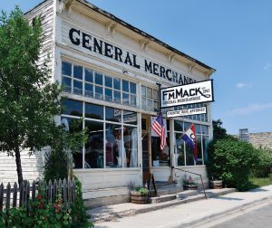
The small town of Augusta — famous for its rowdy summer rodeo — is the supply center for anglers traveling through Sun River country.
Sleepy much of the year, Augusta roars to life during the summer American Legion Rodeo — Montana’s oldest, and declared to be “the wildest one-day show on earth.” The rodeo’s rowdy notoriety rivals Miles City’s Bucking Horse Sale; both attract local cowboys and cowgirls dressed in vintage Western wear, and curious visitors ready to raucously celebrate rural Montana culture. As John Holt explains in Montana Fly Fishing Guide (East): “If you’re in the area … don’t pass up the Augusta Rodeo. Be prepared for a party that goes on ‘forever.’ And the rodeo isn’t too bad, either. One of these affairs in the early 1970s changed my outlook on life.” Or, as Texas singer/songwriter Robert Earl Keen wrote in a different context, “The road goes on forever, and the party never ends.”
Like Augusta, the Sun watershed hides in plain sight, showing multiple, Janus-like faces for anglers willing to probe its beautiful prairies, mountains, and mysteries. An alluring alternative to Montana’s more crowded, marquee waters, the Sun might change your perspective on life too. Bob Marshall, the legendary wilderness advocate who left a profound mark on the region, extolled “the thrill of adventure,” adding “exploration is perhaps the greatest esthetic experience a human being can know.” I couldn’t agree more.
No Comments