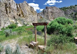
29 Sep Exploring Big Sheep Creek Byway
I put down my walnut pipe and inky zinfandel, rose from our blazing sage campfire, and scanned the horizon for emerging bats. As the western sky melted into a psychedelic watercolor of pink, purple, and orange, last light washed over the highest limestone towers above our primitive campsite. My wife, Mary, and I had discovered an idyllic stream-side refuge on southwest Montana’s Big Sheep Creek, tucked in a rugged canyon threaded by an isolated scenic byway. The evening was ours to observe, enjoy, and marvel at.
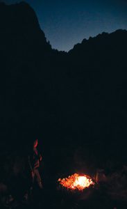
After observing circling bats, the author’s wife, Mary, enjoys a beer around an evening campfire on Big Sheep Creek.
With deep fissures, caves, and overhangs, the sedimentary cliffs presented perfect roosts for bats, along with acrobatic squadrons of swallows flitting above the stream, harvesting hatch remnants for hungry mouths in their nests. As a lifelong fly fisherman, I consider swooping bats and swallows talismans — encores to another angling day, in this case on one of Big Sky Country’s finest spring-fed trout creeks.
But the appearance of bats along Big Sheep Creek carries a little more weight today, in part because they have declined precipitously due to a deadly fungus sweeping like wildfire through their dark resting areas. No sightings as the sun finally faded from the cliffs; I half expected flying monkeys from the Wizard of Oz to take wing from the secretive grottos. Then I excitedly pointed to the sky and alerted Mary, “Look, there they are!” There were just several bats, whirling and twirling through the twilight, but still an actual and metaphorical sign of hope. As Rebecca Solnit explains in her meditative book Hope in the Dark: Untold Histories, Wild Possibilities, “To hope is to give yourself to the future — and that commitment to the future is what makes the present inhabitable.”
Lay and narrative of an uncommon land
If anywhere in Montana remained a stronghold for some of the state’s 15 bat species, I figured it would be the remote, craggy country surrounding the Big Sheep Creek Back Country Byway. Because the caves are mostly small and secluded, there is little chance of tourists or spelunkers tracking fungus into the caverns, though bats can transport infections back to their communal lairs themselves. In addition to bats, chilly limestone caves and honeycombed karst topography provide homes to other unusual plants and animals; in some areas, these even include rare fish, bizarre insects and arachnids, and startlingly pale blind salamanders like those living in Texas and Georgia caves.
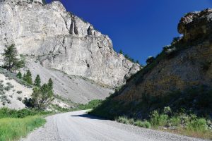
The Big Sheep Byway snakes along and criss-crosses the route of its namesake stream.
The alluring transportation corridor stitching together this spectacular territory is a gravel road winding west out of the tiny town of Dell, situated on I-15 northwest of Monida Pass. The 50-mile route was designated a byway by the Bureau of Land Management (BLM), which manages portions of the surrounding land. In higher terrain along the watershed’s tributary-riven periphery, much of the landscape is encompassed by the Beaverhead-Deerlodge National Forest.
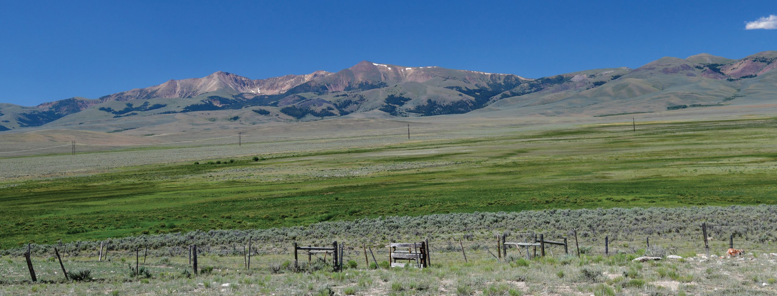
Out of Dell, the byway cuts through a narrow gorge on the southern edge of the Tendoy Range, which rises to 9,674 feet at Dixon Mountain. According to Beverly Magley, in her travel guide Montana Backroads, “The Tendoys display fascinating geology along the road. Convoluted, twisted rocks show the folding and faulting and warping of these Paleozoic and Mesozoic formations. Hoodoos, sheer cliffs, arches, and window rocks decorate the limestone walls.” To the south and west, a maze of Big Sheep feeders drain off the Beaverhead Range, an even more formidable fortress spiked with snow-clad peaks, rearing above 11,000 feet, that separate Montana from Idaho.
In scenes reminiscent of the Pleistocene, pronghorn still race across the broad valleys, though prehistoric cheetahs no longer pursue them; elk graze along the forest edges; golden eagles soar on thermals; sage grouse strut their showy mating dances; sandhill cranes issue primeval croaks; and bighorn sheep patrol high ridges.
The 50-milelong Big Sheep Byway is a BLM road with a gravel surface that’s usually negotiable by passenger cars during good weather.
Native bighorns — documented by Indigenous pictographs — were decimated in recent decades, likely from pneumonia-related ailments transmitted by domestic sheep, a risk that has now been reduced. To help re-establish a herd, Montana Fish, Wildlife & Parks (MT FWP) biologists relocated 26 wild sheep to the Tendoys from Wild Horse Island State Park in 2021. The goal is to release a total of 60 animals that will produce a sustainable population of around 150 sheep. “We’re excited to once again have bighorn sheep in the Tendoys,” says MT FWP’s Dillon-area wildlife biologist, Jesse Newby. “We’re grateful to our many partners for their collaboration, financial support, and volunteerism.” Another sign of hope: resurrecting an iconic beast along its namesake stream and byway.
Rambling the byway is like time-traveling back a century, with no stores, gas stations, or sprawling subdivisions. Visitors are immersed in peaceful, oceanic emptiness — cumulus clouds drifting over the Beaverheads, waves of wildflowers dancing in the wind — with abundant public lands and multigenerational ranches where real cowboys still ride herd in the footsteps of mountain men and Native Americans.
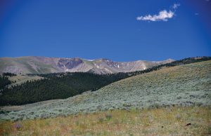
Rising above 11,000 feet, the Beaverhead Mountains form the western backdrop to the Big Sheep Creek Byway, creating a rugged border between southwest Montana and Idaho.
The Tendoy Mountains were christened after Chief Tendoy, who ably led the Lemhi Shoshone band from 1863 until his passing in 1907. Tendoy helped his people navigate a tense and tumultuous period in history when gold miners invaded Native American territory, washing from one boom to another like a human tsunami, while other settlers were homesteading, building railroads, and founding towns.
Southwest Montana was not the clear, undisputed territory of a single Indigenous tribe; rather, it was a trans-Continental Divide crossroads, a zone for groups to relax and regroup on their travels to and from the vast buffalo hunting prairies to the east. Bannock, Crow, Nez Perce, and Blackfeet people utilized the area in addition to the Shoshone.
About midway through the drive, traveling clockwise, the byway crests a divide and drops into the broad headwaters of Medicine Lodge Creek, another trout stream. This segment follows the Old Bannack Road, constructed in 1862 for freight teams transporting supplies between Corinne, Utah and the booming, rowdy gold mining town of Bannack, Montana.
Medicine Lodge twists north toward Horse Prairie Creek and Clark Canyon Reservoir, merging near Camp Fortunate, where Lewis and Clark spent their last days in the upper Missouri basin in August 1805, resting for the grueling trek across the Continental Divide. Like phantoms in much of rural Montana, traces of their stay are now hidden, entombed in the reservoir’s depths.
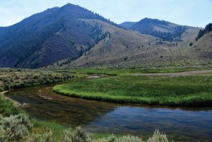
While parts of Big Sheep Creek race through boulder-strewn rapids, other reaches — like this one twisting leisurely through the Tendoy Mountains — display a classic spring creek character, with abundant aquatic vegetation and wary trout.
Doing reconnaissance up a Horse Prairie tributary on August 12, 1805, Lewis came to better appreciate the challenges ahead after ascending Lemhi Pass and surveying present-day Idaho: “… we proceeded on to the top of the dividing ridge from which I discovered immense ranges of high mountains still to the West of us with their tips partially covered with snow.”
Five days later, at Camp Fortunate, the expedition’s fabled Lemhi Shoshone guide and teenage mother, Sacagawea, was at last reunited with her brother, Chief Cameahwait, and fellow tribal members. This was five years after she had been kidnapped by the Hidatsa tribe and taken to North Dakota, seemingly lost for good. Describing the reunion, Clark wrote in his journal that Sacagawea “made signs to me that they were her nation” and “danced for the joyful Sight …” and Lewis added, “the meeting of those people was really affecting. …” The unlikely, fortuitous rendezvous may have saved the expedition, as they were able to secure from Cameahwait the horses they had hoped for and desperately needed to cross the Continental Divide.
A long shot perhaps, but as Solnit observes, “To hope is to gamble. It’s to bet on your futures, on your desires, on the possibility that an open heart and uncertainty is better than gloom and safety. To hope is dangerous, and yet it is the opposite of fear, for to live is to risk.”
Springs, caves, limestone, and productive fisheries
When Lewis and Clark labored upstream in the upper Missouri River basin, streams like Big Sheep in the Red Rock-Beaverhead river drainage pulsed with native westslope cutthroat, Arctic grayling, and mountain whitefish. Today, the grayling are largely ghosts but introduced brown and rainbow trout now figure heavily in the mix. Spring creek stealth and techniques help provide success with wary, well-fed Big Sheep trout. Think small and gossamer light, except during hopper season, when these clumsy insects bring aggressive bruisers to the surface.
According to Rob Thomas, a geology professor at the University of Montana Western, “Geology completely controls the type of trout in Big Sheep.” An avid area fly angler, he notes that the swifter canyon section yields mostly rainbows, while the slower reach around Muddy Creek can surrender good-sized cutts.
Big Sheep Creek is fed by porous limestone aquifers with stable flows, temperatures, and high aquatic productivity fueled by dissolved calcium carbonate.
A perusal of BLM or U.S. Forest Service maps reveals cornucopias of limestone mountain springs feeding both Big Sheep and Medicine Lodge creeks. During the Paleozoic and Mesozoic eras, between 65 and 600 million years ago, thick layers of limestone, dolomite, shale, and sandstone were deposited across much of Montana, Idaho, and Wyoming, including the Tendoys. The region was enveloped by shallow, warm-water seas, teeming with primitive life that absorbed dissolved calcite from the water to form hard protective shells. Seas waxed and waned across millennia; thick layers of dead plants and animals collected on the bottom, eventually solidifying. Limestone was sometimes uplifted to mountaintops by powerful geological forces — like the Tendoy’s Red Rock fault — creating the oddity of ancient shell fossils nearly 2 miles above sea level.
Thomas — who co-authored Roadside Geology of Montana — says the presence of faults is critical for producing springs like those feeding Big Sheep. He observed that widespread, porous Madison limestone is a “major part of the aquifer system in southwest Montana,” further noting that much of this resurfacing bounty “is ancestral water from the late Pleistocene, 9,000 to 10,000 years ago,” the end of the last Ice Age.
Limestone like that soaring above our Big Sheep camp is readily dissolved by natural acidity in rain and groundwater, creating subterranean, Swiss cheese-like conduits for icy flows. Calcium carbonate precipitating out increases the water’s pH, making it more alkaline (hard) than acidic (soft). This chemistry helps generate extraordinarily fecund stream habitats, often sheltering swaying beds of nutrient-rich watercress, creating homes for aquatic insects and crustaceans like scuds — trout menu favorites — or a tasty campfire salad.
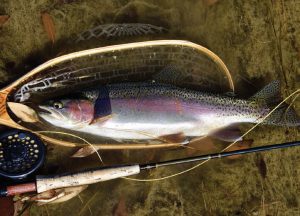
Wild rainbow trout thrive in some of the faster Big Sheep runs, while native westslope cutthroats tend to hang out in slower water.
In his magnum opus, Trout, venerable fly-fishing writer and researcher Ernest Schwiebert explains the molecular effect: “Such basic water chemistry has an immense impact on the quality of a fishery. Except for the character and profusion of aquatic plants, the relative acidity or alkalinity of trout water is invisible, yet the richness of our lakes and rivers depends directly on their lime content. … Poor waters deficient in lime … can grow as little as five pounds of fish per acre annually, while extremely rich waters produce as much as sixty pounds.”
Some of the country’s finest limestone streams in the Northern Rockies, Pennsylvania, and the Upper Midwest’s Driftless Region can be even more fertile, nurturing an astonishing 300 pounds of fish per acre.
During limestone’s subterranean metamorphosis, chemical remnants of ancient sea creatures help reincarnate new life cycles, like colorful cutthroats and the ospreys and river otters that feast on them: destruction, transformation, and rebirth. In his masterful reflections on limestone, trout, death, and living — Jerusalem Creek: Journeys into Driftless Country — Ted Leeson observes that these landscapes “are mausolea, vaulted with caves and stacked with slabs of limestone corpses, their calcified husks leached by rainwater that flows over time and trickles from springs, the mineral remains of a billion creatures cannibalized in the stream below for new shell and bone and exoskeletons.”
In addition to altering water chemistry, limestone beneficially moderates stream flows and temperatures. The sieve-like rock surrounding Big Sheep is an enormous sponge absorbing precipitation, then slowly releasing it in steady, trout-friendly flows. Similar to famous trout tailwaters like the Missouri, Madison, Bighorn, or North Platte, streams heavily fed by limestone aquifers are less likely to whiplash between epic floods and drought-parched trickles. With climate change having a major negative impact on many “flashy” freestone streams, Thomas says stable spring creeks like Big Sheep can play “a significant role for providing a refugium for trout.” Grounds for some optimism.
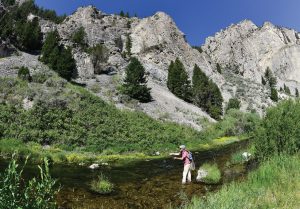
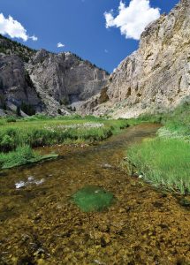
Nestled below towering limestone cliffs, the more open portions of Big Sheep Creek — with adequate casting lanes — are a joy to fish.
Limestone springs, like those in the Tendoys, cool streams during summer heat and warm them in winter, keeping trout in the sweet zone all year. Temperatures in limestone caves and groundwater discharges mirror the area’s average annual surface air temperature: In Montana, this hovers around 50 degrees Fahrenheit, a perfect genesis for a trout stream, particularly when saturated with life-sustaining dissolved oxygen. Optimum trout feeding temperatures generally fall between 55 and 60 degrees, varying by species. With this stability, trout gorge like famished feral hogs, frequently growing 15 to 20 inches long, or perhaps becoming even larger, like those you might see leering down from a wall in a Montana bar.
After a day of fishing under calm, cerulean skies, Mary and I spent our last night camped on Big Sheep Creek, poking our fire and pondering the fickle future, our place within it, and our own responsibilities. The dark worlds of Covid, climate schizophrenia, mass extinction, political dysfunctionality, civil unrest, Ukrainian battlefields, and megalomaniacal dictators began to recede somewhat. Mary scanned the cliffs for replenished bighorn sheep with her binoculars. Then, the bats reappeared against the fading, aquamarine summer sky — bright planets and stars emerging — and I, once again, experienced a feeling and attitude that’s often scarce these days: hopefulness.
As Solnit writes, “Hope just means another world might be possible, not promise, not guaranteed. Hope calls for action; action is impossible without hope.” And this: “Hope is a gift you don’t have to surrender, a power you don’t have to throw away.”
Scenic byways and Trails Windows into our natural and cultural history
Western writer Wallace Stegner famously opined in 1983, “National parks are the best idea we ever had. Absolutely American, absolutely democratic, they reflect us at our best rather than our worst.” The concept of designated scenic byway systems hadn’t fully taken hold then, but Stegner might have made a similar observation about these remarkable routes, like the one shadowing sinuous Big Sheep Creek.
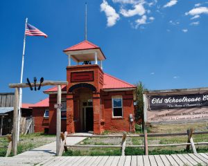
When Big Sheep travelers want a breakfast or lunch not cooked over their camp stove or fire, the Old Schoolhouse Café in the tiny town of Dell beckons nearby with delectable, home-cooked food.
In the early 1990s, before moving to Montana in 1994, I was fortunate to help develop Minnesota’s scenic byway program, which was jump-started by the 1991 federal transportation bill. It proved to be some of the most satisfying work of my career, in part because I was — and have remained — a fan of the “win-win” byway concept: The corridors not only celebrate scenic beauty and roads perfectly integrated with the landscape, but link together significant natural, cultural, and recreational resources, providing an economic boost to communities along the way. Astute grant writers can often secure funding to protect, enhance, and interpret resources along these routes, with designations occurring at the federal and state levels, and local governments often nominating candidates through a grassroots process.
In the Northern Rockies, byways are often designated by the U.S. Forest Service or BLM and typically offer more remote, less developed experiences. In addition to Big Sheep, Montana’s BLM byways include Missouri Breaks and Big Sky (i.e., Terry Badlands) in the east, and Garnet in the northwest. Designated U.S. Forest Service routes include the Beartooth, Kings Hill (Little Belt Mountains), Lake Koocanusa, Pioneer Mountains, and St. Regis-Paradise (Clark Fork River) scenic byways.
While having lunch at Dell’s friendly Old Schoolhouse Café, Mary and I also got an alternate taste of Big Sheep’s recreational diversity. We met a Canadian woman biking the backroads from Alberta to Mexico on the Great Divide Mountain Bike Route, which includes the Big Sheep Byway. Missoula’s Adventure Cycling Association — which developed and mapped the trail — characterizes the journey as “the longest off-pavement route in the world. … Its remoteness equates with spectacular terrain and scenery.” It winds 3,090 miles along the Continental Divide — from Jasper, Alberta to Antelope Wells, New Mexico — with a total of over 200,000 feet in elevation gain.
After quaffing lemonade and replenishing burned calories, the Canadian vagabond reflected on her morning ride over the divide between the Medicine Lodge and Big Sheep drainages: “Wow, that was quite the climb! I didn’t think it was ever going to end.” While her journey was still young, with many more mountain workouts, she was hopeful she would make it to Mexico. According to Solnit, “Hope locates itself in the premises that we don’t know what will happen and that in the spaciousness of uncertainty is room to act. When you recognize uncertainty, you recognize that you may be able to influence the outcomes.”
Higher above Big Sheep Creek, near the Idaho border, the Continental Divide National Scenic Trail winds through the mountains, a draw for both day hikers and indefatigable through-backpackers making the 3,100-mile trek in a single season. The unique path, parts of which are also used by equestrians and mountain bikers, is one of only 11 long-distance National Scenic Trails designated by Congress. According to the 1966 Trails for America Report — which helped lay the foundation for establishing the system two years later — “Each National Scenic Trail should stand out in its own right as a recreation resource of superlative quality and of physical challenge.”
Navigating Big Sheep Creek Byway
While the Big Sheep Creek Back Country Byway snakes through secluded, expansive terrain, it’s easily accessible from either end (via BLM route 302 or Medicine Lodge Road). To the south, the gateway is Dell. The north portal runs south from Beaverhead County Road 324, west of Clark Canyon Reservoir. During dry weather, the byway is navigable with a passenger car, although higher clearance and four-wheel drive will help with exploring nearby backroads. Drivers may need to patiently wait for livestock like sheep to amble across the road.
Travelers should pack everything they need for their trip because there are no services. Limited supplies are available in Dell (a sign on the Dell Merc puts the population at 35). The town was founded as a station of the Utah & Northern Railway, which reached Butte in 1881. Dell’s Old Schoolhouse Café is well worth a stop for a homemade breakfast or lunch, with delicious pies and sourdough bread also available. The historic building was filled with lively schoolchildren from 1903 to 1963 before being converted to other uses.
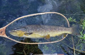
The fertile water in Big Sheep Creek is capable of producing abundant and sometimes sizable trout — like this wild brown — some of which make spawn-ing runs up from the Red Rock River.
Because of its collection of eccentric old buildings, nearby Lima (population 212) is an interesting town to wander through with a camera, a little lost world perched at 6,257 feet. Like Dell, Lima was also a railroad town, with maintenance facilities including a roundhouse and machine shop. For a vintage Montana tavern experience, drop in at The Peat Bar and Steakhouse, where lodging is also available.
Along the byway there is a small BLM campground at Deadwood Gulch, with picnic tables, fire pits, and an outhouse (but no water). Primitive camping along Big Sheep Creek is available on BLM parcels scattered among private land. Prospective campers should bring a GPS or BLM or
Beaverhead-Deerlodge National Forest map to locate public land and avoid trespassing. More developed camping options and trout fishing are also available at nearby Clark Canyon Reservoir, with a publicly accessible shoreline and boat ramps managed by the U.S. Bureau of Reclamation.
There is a maze of rustic roads branching off from the byway, providing access to Big Sheep tributaries and many square miles of BLM and U.S. Forest Service land. Among the most popular destinations is Morrison Lake, tucked 2 miles east of the Idaho border at 8,377 feet, which is accessed via a rough U.S. Forest Service road (#3920). Some make the sojourn for both fishing and primitive camping. Morrison is a deep, clear lake with no inlet or outlet for trout spawning. Consequently, MT FWP stocks 2,500 westslope cutthroat every four years, some of which attain hefty size, averaging around 16 inches.
Another scenic side trip in the area is the U.S. Forest Service road (#3929) that winds up Little Sheep Creek, which can be accessed on the west side of Lima. There is a small, quiet campground (East Creek) on a Little Sheep tributary, although much of the water in this drainage is too small to fish unless you discover a beaver pond. A lightly used trail at the end of the road leads deep into the headwaters, below 10,961-foot-high Garfield Mountain and the stunning, scree-laden, snowcapped Lima Peaks.
Rana Worden
Posted at 23:41h, 31 MayReading this, I found my Montana Gazetteer and started planning for summer 2024.. What an excellent description of your journey, and I almost felt I was there with you. My heart and soul for discovery has been enlightened! Thank you!
Rana Worden,
Dillon, Montana