30 Jan Excursion: Close Encounters on Racetrack Creek
Tucked into the cozy down sleeping bag in my vintage 1977 Toyota Chinook micro-camper, I yawned, rolled over, and pondered morning coffee. My awakening consciousness was startled by loud clawing outside the camper. I looked out the open window. A grizzly bear’s moist snout was 3 inches from my face, separated by only a flimsy insect screen.
The bruin was standing on its hind legs, paws on the side of the camper, staring directly at me. I yelled, “Go, git, scram!” But the bear failed to understand plain English. Then, I pounded on the ceiling trying to scare the animal, but it held its ground, still gaping. Finally, I grabbed a fly rod case, shoved it through the pass-through window of the camper and into the cab, and wielded it to blast the steering wheel horn. That did the trick, and the bear scampered off into its forest home in western Montana’s Flint Creek Range.
So, did I dare resume my Racetrack Creek fly-fishing adventures with a grizzly roaming the area?
Rambling Through the Flint Creek Range’s Vast Geography
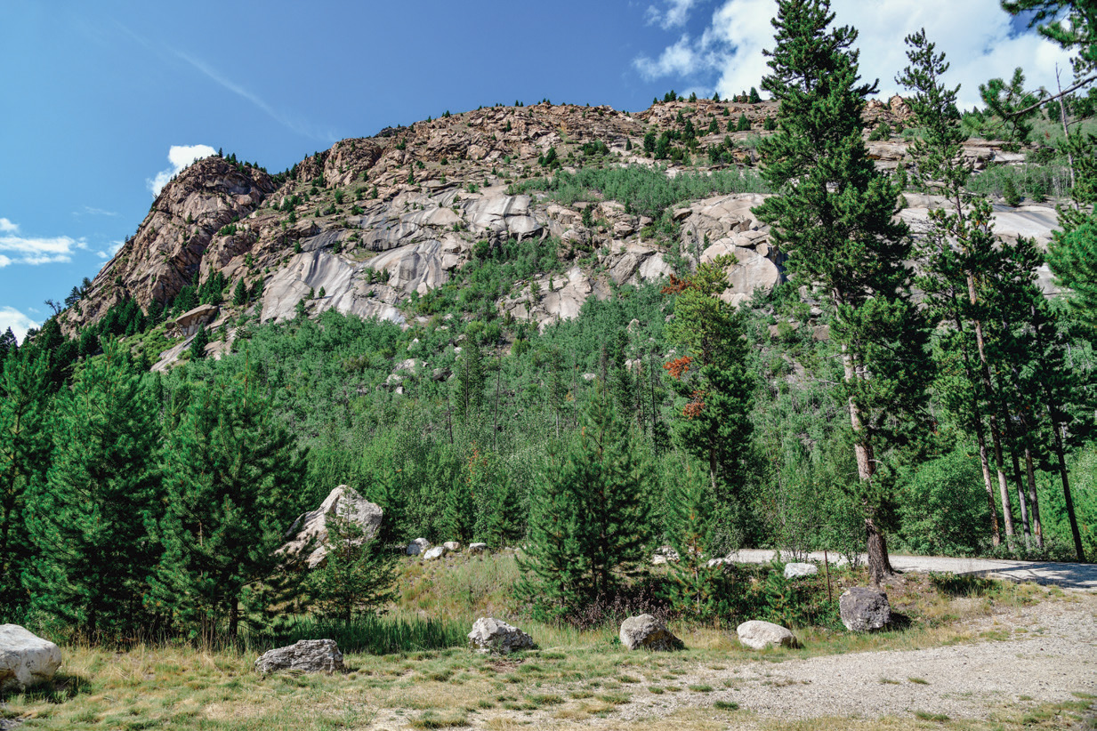
Given their rugged, sprawling, snow-capped magnificence, the Flint Creek Range mountains are perhaps underappreciated, not the rock stars the Bridgers, Beartooths, or Absarokas are in the public imagination. Rising to 10,168 feet at Mount Powell, this range — nestled between Butte and Missoula, Montana — offers a myriad of alpine trout lakes and streams directly feeding the Clark Fork River on the east and doing the same via Flint Creek off the west slope.
Largely encompassed by the Beaverhead-Deerlodge National Forest, the range contains several developed U.S. Forest Service campgrounds for fly anglers, including Racetrack, where I was camped. Upstream, accessed by a primitive road, is a historic one-room log Forest Service rental cabin, and further still, the headwaters at Racetrack Lake. Tucked on the southeast edge of the Flints is Lost Creek State Park, with spectacular views of the surrounding peaks, a waterfall, a small trout stream, trails, and an enticing campground. And scattered throughout the range are abundant primitive camping opportunities.
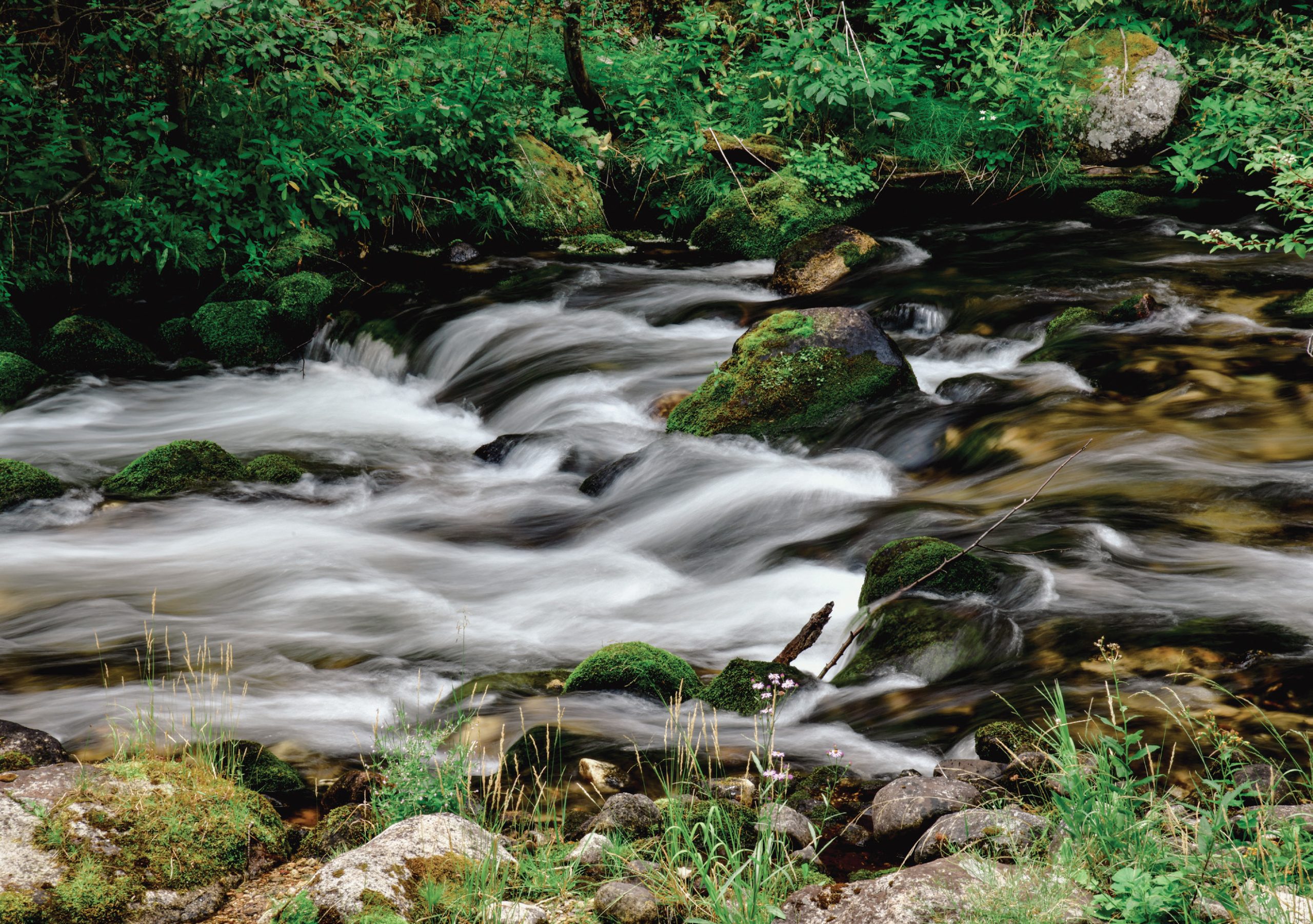
On its 23-mile run from the high peaks of the Flint Creek Range to the Clark Fork River, Racetrack Creek starts out fast but mellows out as it gets closer to its mouth, sometimes even going dry.
The Flint Creek mountains were created by the same massive, eastward-moving thrust fault that helped mold the nearby Bitterroot, Garnet, Anaconda, and Pintler ranges. The Flints have a volcanic granitic batholith intrusion on top, with ancient oceanic sedimentary layers underneath, including limestone, helping jump-start aquatic productivity.
David Alt and Donald Hyndman, authors of Roadside Geology of Montana, describe the Flints’ creation as follows: “Ice age glaciers that gouged the high valleys of the Flint Creek Range descended to the elevation of the valley floor. They left their signature in the deeply carved high peaks, sharp ridges, and valleys shaped like deep troughs. Hummocky moraines littered with erratic boulders spread around the mouths of the canyons.”
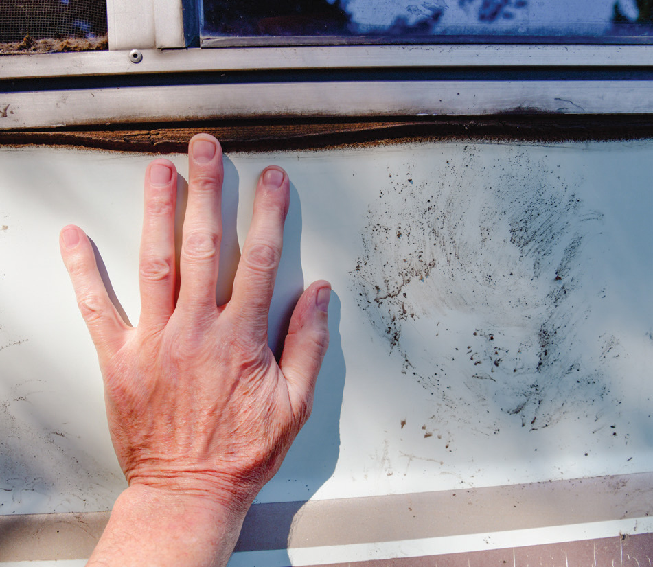
The author came face-to-face with a grizzly while camping near Racetrack. The bruin reared on its hind legs, muddy paws on the author’s camper, snout only inches away from the author’s face. The paw prints lasted months before finally washing away by thunderstorms. They became a show-and-tell piece for fellow campers, friends, and neighbors: “You mean the bear was actually looking at you from right there?”
In addition to voluminous, glacially sculpted trout waters, the range produced gold, silver, lead, zinc, tungsten, molybdenum, and phosphate. Gold Creek, at the northern edge of the Flints, was the site of Montana’s first placer gold discovery in 1852 and was later worked over by two large dredges in the 1930s, one shipped on 42 rail cars to the now desolate mining town of Pioneer.
Located at the southern edge of the Flint Creek Range, Lost Creek State Park features trails and an excellent campground. The peaks and ridges rearing above the park display a remarkable, severely contorted geology.
Partly because of the deep mining history in the Flints, a maze of primitive roads and inholdings penetrates deep into the mountains, similar to Montana’s Tobacco Root Range to the southeast. But, like those mountains, there are also vast areas that are essentially wilderness, even though they haven’t been officially designated. So day hikers, backpackers, and equestrians have plenty of room to roam on trails leading to backcountry lakes, creeks, primitive campsites, and spectacular vistas. Similarly, off-highway vehicle fans have many exploratory opportunities on the sometimes-rough roads. To assess the roads, trails, and fishing opportunities, obtain the Beaverhead-Deerlodge National Forest map for the northern district. Otherwise — in the absence of cell phone coverage — you might execute the former Montana tourism slogan: “Get Lost.”
Diverse Trout and Wildlife Habitat
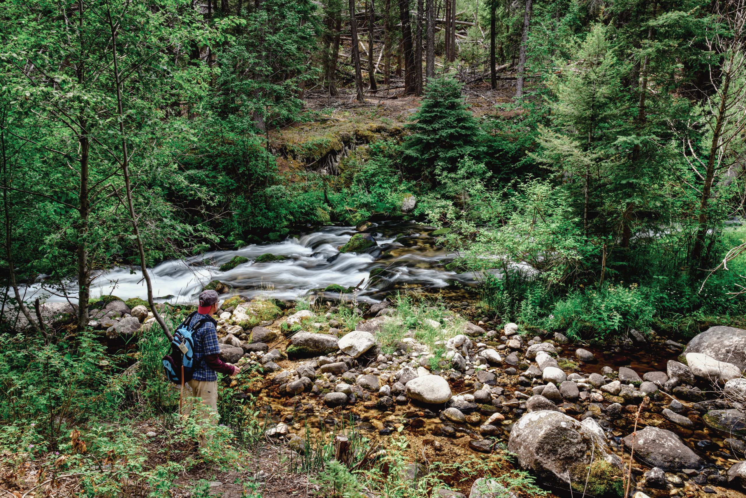
For those who love fishing for a variety of salmonids, the Flint Creek Range is the proverbial cat’s meow. The mountains support introduced brook, brown, and rainbow trout; native westslope cutthroat and protected bull trout; and under-appreciated mountain whitefish. Streams are small, calling for light 2- to 5-weight wands; the constellation of mountain lakes sometimes requires slightly heavier gear, such as a 6-weight, and perhaps a float tube, canoe, or kayak. Upper Racetrack Creek can be fast and bouldery, so you may need to drop your bug in bathtub-sized pockets and be prepared for quick strikes, because the trout don’t have much time to decide on their next meal.
Important conservation work blossomed on the 23-mile-long Racetrack: A key 131-acre inholding just downstream from the Racetrack Campground was purchased by the Western Rivers Conservancy (WRC) in 2023, then sold to the Beaverhead-Deerlodge National Forest in 2025. According to Allen Law, the interior west project manager for WRC, “Because of its top-notch fish and wildlife habitat and its recreational value, the Beaverhead-Deerlodge National Forest wanted to acquire this inholding for years. … We were able to buy the property and then partner with the national forest to make that vision a reality. We’re thrilled to see this special place conserved and open for Montanans to fish, hunt, and otherwise explore and enjoy.”
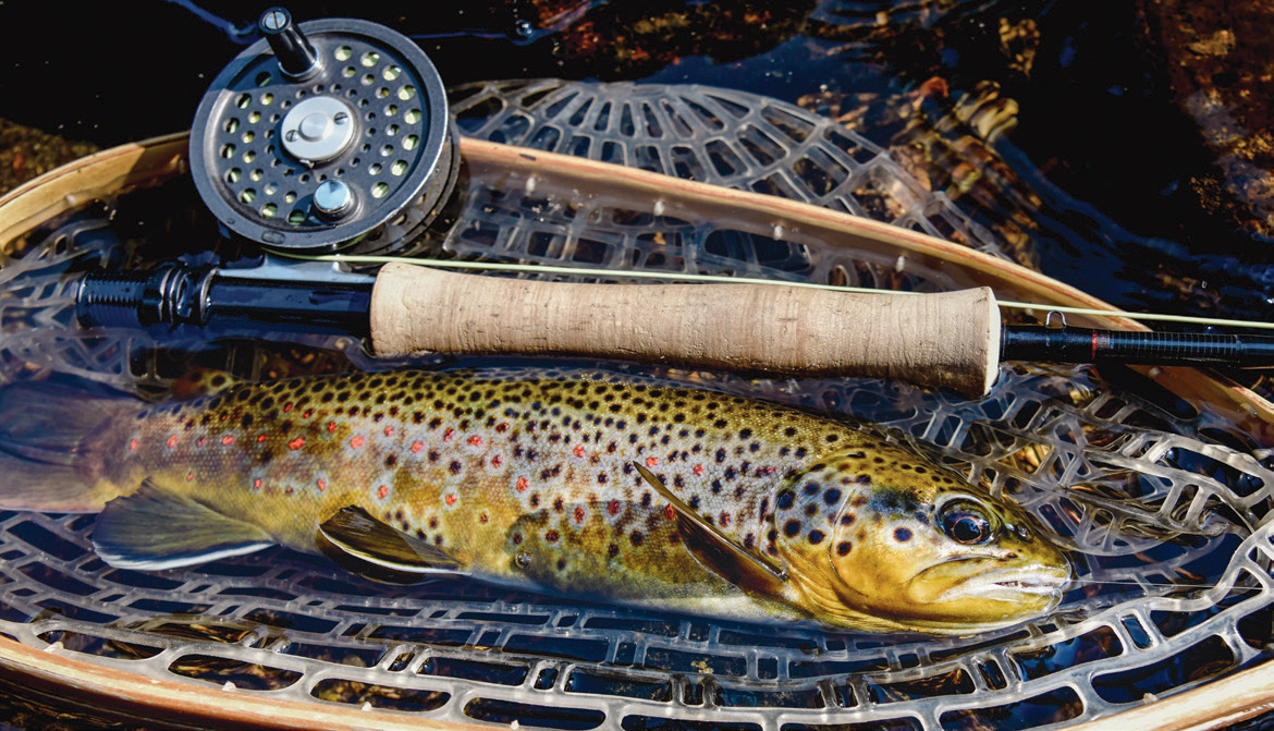
Westslope cutthroats and protected bull trout are indigenous to the Flints, along with mountain whitefish. Introduced species like brook, brown (pictured), and rainbow trout are common. Often, they have outcompeted natives and — in the case of rainbows — hybridized with cutthroats, diminishing their genetic integrity.
This section is a transition zone where Racetrack morphs from a swifter, steeper headwater stretch to a slower, more serpentine stream. The willow-lined reach — called “The Oxbows” — provides good habitat for moose and beaver. The surrounding landscape also hosts mountain lions, mountain goats, bighorn sheep, elk, mule deer, black bears, and blue grouse.
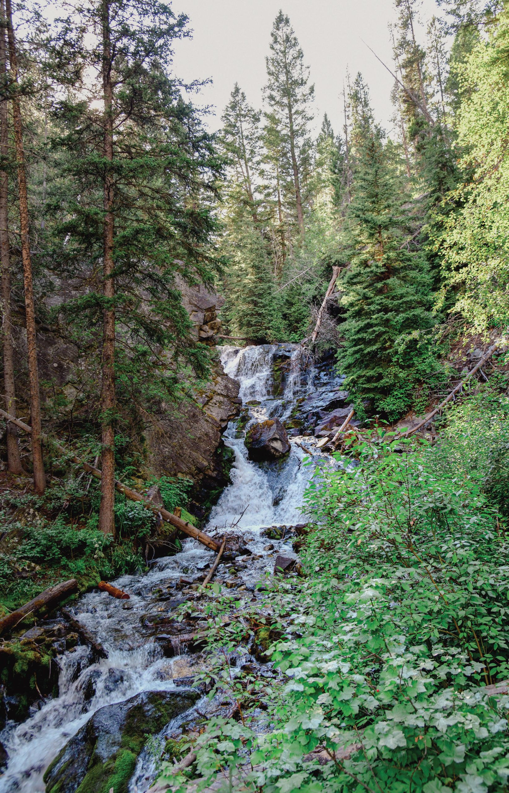
Lost Creek State Park is an alluring escape for vagabonds, hikers, and anglers who like small streams and waterfalls.
Racetrack has also benefited from habitat improvement work, and the Clark Fork Coalition has secured water rights to improve instream flows, which will help indigenous westslope cutts and bull trout. Because of irrigation demands during dry summers, lower Racetrack sometimes goes dry before reaching the Clark Fork River, depriving the latter of cold, rejuvenating water.
Racetrack Creek is important to the beleaguered Clark Fork fishery, where biologists are seeing diminished trout numbers. A multimillion-dollar restoration project has been underway for years on the Clark Fork, a federal Superfund corridor, to remediate historic damage from waste washed downstream from the Butte copper mines and Anaconda smelter. In the short term, the ongoing work has disrupted the riparian area, but over time, the efforts should help the fishery.
(Politely) Say ‘Howdy Doody’ to Mr. and Ms. Grizz
While I wasn’t expecting a grizzly face-to-face, I shouldn’t have been surprised. The morning before my encounter, I was at the picnic table working on camp chores when I noticed a pickup stop nearby, the folks staring at something. I was at the quiet, isolated end of the loop, so it seemed a little odd.
Curious, I went over and visited with the friendly driver. “I don’t want to alarm you, but there’s a grizzly bear right over there,” he said, pointing to a spot a hundred feet from my camper. I thanked him for the warning and retreated to the camper for an hour, never actually seeing the bear in the underbrush. It occurred to me that the night before, when I was happily hanging out around the campfire, the beast could have been lurking nearby, monitoring my activities. But none of this stopped me from fishing Racetrack Creek the next day, pulling in feisty trout.
Grizzly bears have been steadily returning to their historic range in Montana since they were listed for protection under the federal Endangered Species Act (ESA) in 1975. The animals are venturing deep into the Great Plains east of the Rocky Mountain Front. They’ve also been gradually establishing a foothold in the mountains and valleys between their strongholds in the Northern Continental Divide Ecosystem (NCDE) — the greater Glacier National Park/Bob Marshall Wilderness region — and the Greater Yellowstone Ecosystem (GYE), including parts of Wyoming and Idaho. A couple of decades ago, campers wouldn’t expect to see a grizzly in the Flints, but that’s changed.
According to a recent grizzly bear map compiled by Montana Fish, Wildlife & Parks (MT FWP), the Flints are either in “estimated grizzly range” or an area of “grizzly sightings.” In the September–October 2025 issue of MT FWP’s Montana Outdoors magazine, agency director Christy Clark reported that grizzly numbers in the NCDE have risen from fewer than 200 in 1975 to 1,200 today. In the GYE, numbers have increased during that same 50-year period, from approximately 136 bears to more than 1,000. These days, astute campers, hikers, hunters, and anglers pack bear spray and keep a clean camp when roaming around western Montana, and now further east, too.
After I returned from my road trip, I contacted a couple of MT FWP and Forest Service bear biologists to report my encounter. At the time of the conversations (summer of 2024), the bear had not caused any more reported problems. That’s fortunate, because increasingly we need to coexist with these powerful, magnificent animals as they reclaim their range, whether they remain listed under the ESA or not — a hotly debated topic these days.
After my close grizzly encounter, I didn’t feel comfortable continuing to roam remote Racetrack Creek with my fly rod. I raised the white flag and, as I left the campground, posted a note on the entrance bulletin board: “Attention, a grizzly bear was in the campground this morning. It caused no problems, but be aware and careful.”
I headed south to Lost Creek State Park. A friendly family stopped by my iconic camper for a tour, which happens all the time given its age and rarity. I also showed them the fresh grizzly paw prints on the side. The father was astonished. “Wow, we were at the Racetrack Campground today, looking for a site. But I saw the note you left and decided no way do I want my kids running around with that grizzly in the area,” he admitted. “So, we came here, too.”
For months, I had the bear’s muddy paw prints on the side of my camper, lingering proof of the encounter that I proudly showed off like an explorer’s badge of honor to fellow campers, friends, and neighbors. Ultimately, I think the bruin — which did no damage nor pillaged any food — was just curious. I respect benign curiosity, whether from a bear, cat, or human. Perhaps the grizz was just thinking, I’ve never seen such a cool old camper before: I wonder what’s in there, who owns it, and how the fishing is.

Grant-Kohrs National Historic Site | ZACK FRANK
Roaming the Flints
While not fly fishing the Flint Creek Range, there’s plenty to explore on the perimeter. The mountains are lined by a necklace of towns, not exactly Montana metropolises but with their own charm, curiosities, and attractions. There’s tiny Drummond on the north end, Deer Lodge on the east side, Anaconda hugging the south, and Philipsburg on the west face.
“P-burg” has strategically resurrected itself from its fading mining past into a compelling travelers’ destination, with colorful Victorian buildings, bars, restaurants, and shops. It’s the county seat of Granite County, with a modest population just north of 900. The town was christened after mining engineer Philip Deidesheimer, who designed the ore smelter that helped build the town. Productive Flint Creek flows nearby for fly anglers.
Anaconda is an inviting, historic town established in 1883 by “Copper King” Marcus Daly as a smelter operation for Butte ore. The Anaconda operation was expanded in 1919, with a new smelter and a 585-foot-tall smokestack, the world’s largest masonry structure. Peak production occurred during World War II: The smelter generated more than 25 million pounds of copper per month, helping electrify American warplanes and ships while employing approximately 2,500 workers. The smelter finally closed in 1980, and the stack — soaring like a bizarre minaret over the town — was later designated a state park. Warm Springs Creek, a trout stream with headwaters in the Flints, runs right through town.
Deer Lodge, perched at 4,538 feet and adjacent to Interstate 15 and the Clark Fork River, is home to a place you never want to do time: the Montana State Prison. But the forbidding, fortress-like Old Montana Prison is open to public visits, as is the Montana Auto Museum. According to the Montana Historical Society (in <IT>Montana Place Names from Alzada to Zortman: A Montana Historical Society Guide<IT>), the Shoshone tribe called the area “It Soo’-Ke-En Car’-Ne,” or “lodge of the whitetail deer.”
Nearby is the Grant-Kohrs National Historic Site — once home to “Cattle King” Grant Kohrs, who owned more than a million acres in Montana, Wyoming, and Alberta — dedicated to interpreting Big Sky Country’s frontier ranching story. The Mullan Road, a wagon freight route completed in 1862 and running from Fort Benton, Montana to Walla Walla, Washington, also skirts the Flints. Its designer, Captain John Mullan, was characterized this way by the Montana Historical Society (in Montana’s Historical Highway Markers):
Mullan himself might have been incredulous had he seen the freight train that crossed this divide in 1865. Seven camels, each laden with 600 pounds of flour, made the trek from Helena to the Deer Lodge miners. One of the less successful experiments in American transportation history, the dromedary carried tremendous loads, was sure-footed, and had great stamina, but the horses, mules, and oxen of the teamsters and mule train packers stampeded at the sight and smell of them. The camels were gone from Montana by 1867.
And then there’s Drummond, offering views of the Flints looking south, and a good place to fill the tank and replenish the beer supply. Drummond is one of the embarkation points for the Pintler Veterans’ Memorial Scenic Highway (State Highway 1), which runs south along Flint Creek to P-Burg, Georgetown Lake, and, finally, Anaconda, circumnavigating the west and south sides of the Flints. Along the way is the steep, winding road to Granite State Park, a remnant silver mining outpost and ghost town. Settled in 1872, Granite held 3,000 people by 1890, but they vanished during the 1893 silver-market crash. Montana State Parks explains the boom-and-bust story this way:
This was the richest silver mine on the earth, and it might never have been discovered if a telegram from the east hadn’t been delayed. The miner’s backers thought the venture was hopeless and ordered an end to its operation, but since that message was delayed the miners worked on and the last blast on the last shift uncovered a bonanza, which yielded $40,000,000.
Skill, perseverance, and intelligence are critically important, but doses of unexpected luck help on the rough backroads of life, too.
Jeff Erickson has logged thousands of road miles and 16 years as an environmental, land use, and outdoor recreation planner in Montana and Minnesota. In addition, his stories and photographs have been published in Montana Outdoors, Fly Fisherman, Fly Rod & Reel, and many other publications.
No Comments