29 May Wind River Range
The Winds, as Wyoming’s largest mountain range is affectionately known, straddle the Continental Divide for their entire length, extending approximately 110 miles from Togwotee Pass to South Pass. They also contain the loftiest assemblage of peaks in the American Rockies outside of Colorado. According to Joe Kelsey, the author of Wyoming’s Wind River Range, 26 mountains in the Cowboy State exceed 13,000 feet in elevation and “rise at least 500 feet from any saddle connecting them to a higher peak.” Twenty-three of the 13ers are located in the Winds, and 21 cluster “within 9 miles of one another on or near the Divide southeast of Squaretop [Mountain].” Given their high elevation and northerly latitude, this portion of the northern Winds comprises the “most rugged and glaciated mountainscape in the American Rockies,” according to the authors of the website peakbagger.com.
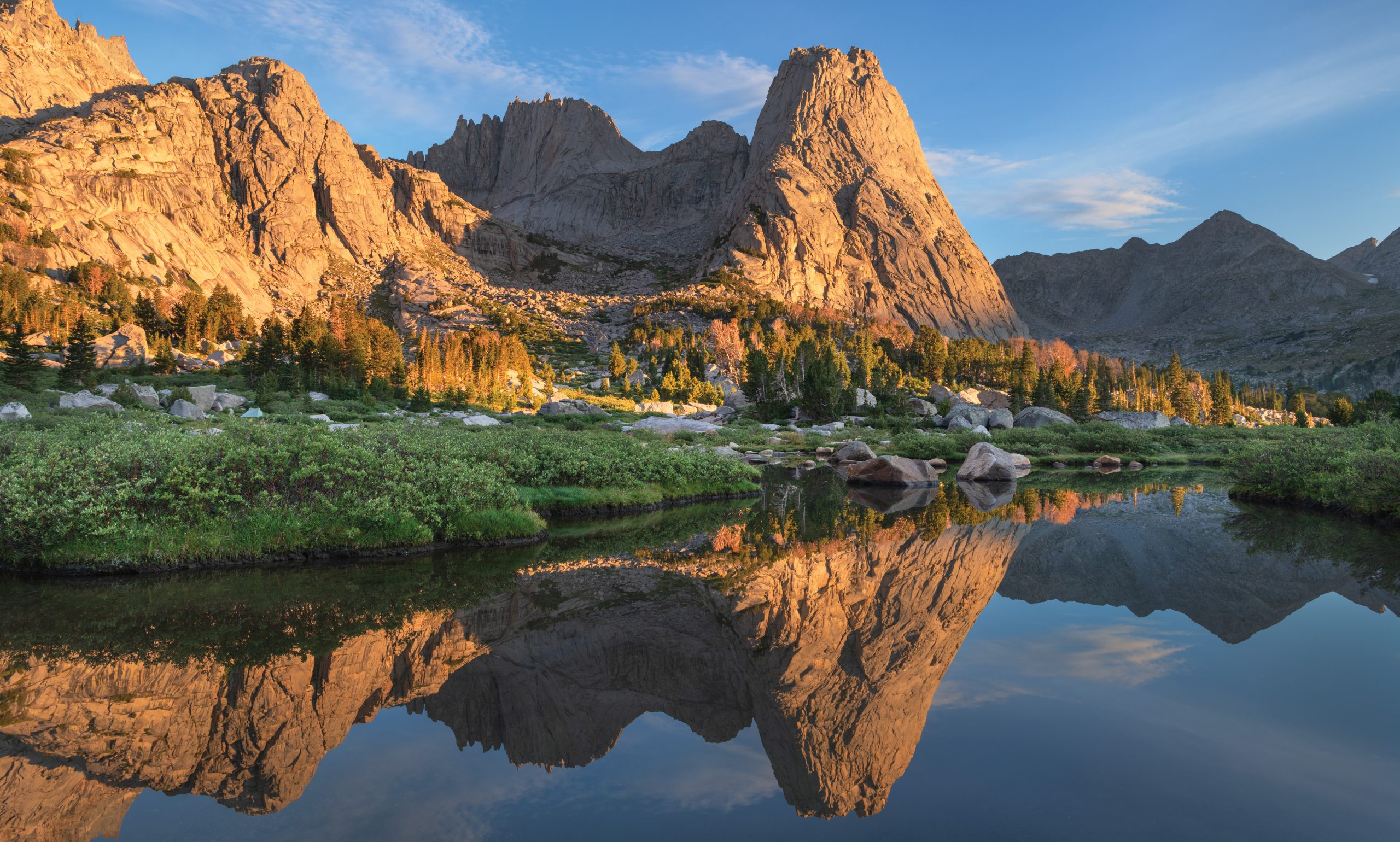
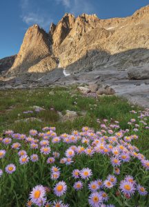
Squaretop Mountain’s distinctive profile is synonymous with the upper Green River Valley and, arguably, the entire Wind River Range. Viewed, however, from the head of lower Green River Lake, the visual prominence of its towering summit (11,695 feet) belies the fact that Squaretop is 8 miles from that signature vantage point and rises 3,734 feet above the lake’s surface. | Photo by ALAN MAJCHROWICZ
Annual visitation to the Winds, however, is a tiny fraction of that received by Yellowstone and the Tetons, despite their close proximity to each other. That discrepancy is almost entirely attributable to the remoteness of the Wind River Range. Indeed, its crest is not traversed, at any point, by a paved road. Trailheads in this area are often more than 50 miles from the nearest town, and lengthy approach routes further reduce access to the highest and most spectacular portions of the Winds. Those characteristics facilitate solitude amid the breathtaking beauty of the Wind River Range. Consequently, these mountains are a destination revered for decades by members of the mountaineering, climbing, and backpacking communities.
Immersion in a wilderness as vast and picturesque as the Winds quickly establishes an indelible impression on the human psyche. David Muench, a renowned landscape photographer, describes this sprawling range as a “sacred place, [one] of huge, exquisite beauty.” Subsumed within the broader context of the Rockies, the Winds are, in the opinion of James R. Udall, a “great alpine cathedral with the architecture to invigorate our souls.” Wildlife biologist Tom Segerstrom astutely observes that the Winds provide an increasingly priceless resource: the opportunity to “experience untamed wildness, [which] will become the rarest commodity of this century.”
Mountain and rock climbers — as well as backpackers, anglers, hunters, and horse packers — historically account for a large percentage of recreational visits to the Winds. Hopefully, commentary on the following destinations will pique the interest of a much wider readership, including motorists, day hikers, landscape photographers, students of history, fall-
foliage connoisseurs, and wildlife aficionados.
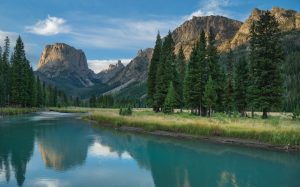
Squaretop Mountain and the Green River Lakes
Accentuated by the distinctive profile of Squaretop Mountain (11,695 feet), the view from the head of lower Green River Lake encompasses the most uniquely recognizable landscape in the Wind River Range. This iconic destination is 52 miles from the nearest town, thus affording a measure of solitude that is rarely obtainable via vehicular traffic in the contiguous U.S. From Pinedale, head northwest on U.S. Highway 191 to its junction with Wyoming Route 352. Turn right and follow the latter road for 25.3 miles to the boundary of Bridger–Teton National Forest, where the pavement ends. The road is designated thereafter as the Green River Lakes Road, and visitors can continue for 18.5 increasingly rough miles to the boat-launch road, which begins at the Green River Lakes Recreation Area entrance.
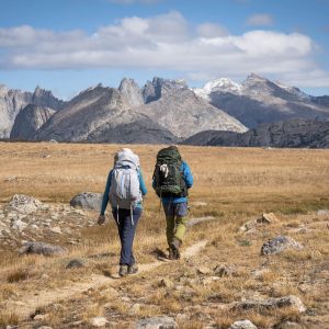
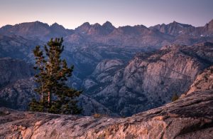
The Highline/Fremont Trail is the centerpiece of an extensive network of trails that traverse some 720,000 acres of federally designated wilderness in the Winds. The west side of the serrated crest of the Cirque of the Towers, which these hikers are looking toward, is most visible from the portion of the Fremont Trail that passes near the head of Washakie Creek. | Photo by JACK BRAUER
The adjoining campground is usually open as a full-service facility from June 15 to September 15. Several trails are also accessible from the road’s end. A popular route combines portions of the Highline and Lakeside trails to form a 6.2-mile loop around lower Green River Lake. For the most scenic views, follow Highline Trail — which is described more fully below — on the outbound leg of your trek. Scattered stands of aspens and cottonwoods become visible roughly 1 mile from the trailhead. According to landscape photographer Daryl L. Hunter, peak color in this area tends to occur around September 20.
Pictured here are Mount Helen (13,620 feet) and purple asters in the Upper Titcomb Basin of the Bridger Wilderness. According to landscape photographer Alan Majchrowicz, “Few places in North America are as staggeringly beautiful as Titcomb Basin and Island Lake.” Such environments are, as John Fielder observes, “our psychological bedrock.” They are “places that [seemingly] never change, no matter what chaos we create in the rest of our lives.” | Photo by ALAN MAJCHROWICZ
Gannett Peak
As the capstone of the northern Winds, Gannett Peak’s summit (13,804 feet) marks the apex of this rugged range, the state of Wyoming, and, except for Colorado, the American Rockies. A successful ascent of this giant is a significant mountaineering accomplishment. Among state high points, only Granite Peak in Montana, Mount Rainier in Washington, and Denali in Alaska pose technical challenges as formidable as those presented by Gannett Peak.
For visitors who can allocate only one itinerary day to backcountry activities, a superb option is the segment of the Pole Creek Trail from Elkhart Park to Photographer’s Point(pictured here; 10,350 feet). After a gradual, 4-mile ascent through forests, hikers are rewarded with this dramatic view of the Fremont Creek canyon and, to the northeast, a host of 13,000-foot peaks located on or near the Continental Divide. | Photo by JACK BRAUER
All approach routes involve, at minimum, round-trip hikes of 40 miles. Consequently, no high point, including Denali, is more isolated than Gannett. Suitable campsites are unavailable on this mountain, so be prepared for a long and grueling summit day, devoted almost exclusively to hiking on snow and ice. Indeed, Gannett Peak is flanked by five glaciers, which constitute the largest single concentration of glacial ice in the American Rockies. Therefore, expertise with ice axes and crampons is essential for a safe ascent. For technical advice on climbing routes, readers should consult the numerous guidebooks available for the Wind River Range.
Cirque of the Towers
Given its status as a rock-climbing mecca, the Cirque of the Towers receives a steady stream of visitors during the summer. Located in the southern Winds, this semicircular array of 15 12,000-foot peaks is also a bucket-list destination for many backpackers and hikers. Evocative toponyms, such as Sharks Nose, War Bonnet, and Lizard Head, contribute to the mystique of these granite spires, big walls, and craggy peaks. Their tightly nested configuration resembles the spectacular Valley of Ten Peaks in Alberta’s Banff National Park.
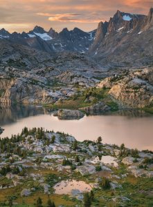
The breathtaking beauty of the area surrounding Island Lake — its raw, freshly glaciated landscape and granitic core — are distinctly reminiscent of the High Sierra. Given the fact that it is accessible via a 12.1-mile, one-day hike from Elkhart Park, Island Lake is an extremely popular destination. This site also serves as an excellent base camp for exploration of the stunning Titcomb and Indian basins. | Photo by ALAN MAJCHROWICZ
The Big Sandy Trailhead, located approximately 55 miles east-southeast of Pinedale, serves as the primary conduit for this area, with portions of the Big Sandy and Jackass Pass trails receiving the heaviest traffic. At Jackass Pass (10,790 feet), the glorious mountainscape delineated by the cirque becomes fully visible before the trail rapidly descends to Lonesome Lake. From the east, the North Fork Trail is less frequently employed as an approach route. For most of its length, the latter trail follows the North Popo Agie River west from Dickinson Park to Lizard Head Meadows and, ultimately, Lonesome Lake. Climbers venturing into this area for the first time may want to consult Steve Bechtel’s guidebook Cirque of the Towers & Deep Lake: A Select Guide to the Wind Rivers’ Best Rock Climbing.
Skyline Drive, Elkhart Park, and Photographer’s Point
For travelers with neither the time, inclination, nor ability to engage in multi-day backcountry excursions, this area should be a focal point of any Wind River itinerary. The 14.3-mile Skyline Drive begins at Pinedale and ends at the Elkhart Park Trailhead. Just prior to its terminus, a pullout affords perhaps the best glimpses of the craggy heart of the Wind River Range that are available from any paved road. Therein, an interpretive plaque identifies the visible summits of Fremont Peak (13,745 feet), Mount Warren (13,722 feet), Mount Helen (13,620 feet), and six other 13ers. The last portion of this road also provides excellent fall-foliage viewing opportunities in late September, when aspens exhibit peak color.
The 4.6-mile section of the Pole Creek Trail from Elkhart Park to Photographer’s Point offers a bite-sized sample of the Winds’ backcountry. Island Lake and the Titcomb Basin are extremely popular but more distant destinations that are accessible from Elkhart Park via portions of the Pole Creek, Seneca Lake, Highline, and Indian Pass trails. Ben Adkison, the author of Hiking Wyoming’s Wind River Range: A Guide to the Area’s Greatest Hiking Adventures, regards the Titcomb Basin Trail as preeminent among the Winds’ “many spectacular alpine trails [for its] ease of access and [grandeur of scenery].”
Highline Trail
With approximately 720,000 acres of federally designated wilderness, the Wind River Range is a backpacker’s paradise. For hikers who seek a truly immersive experience, the Highline Trail is a popular choice. This 64-mile segment of the Continental Divide Trail runs from Green River Lakes south to the Big Sandy Trailhead; it follows a bench (or terrace) that parallels the range’s crest on its west side. Adkison describes the 11.2-mile section between Little Seneca and Summit lakes as “arguably the most spectacular trail in the range,” one that crosses a “raw landscape of alpine lake basins seemingly just released from the grip of an ice age.”
The Highline Trail is also remarkably level. With few exceptions, it traverses terrain between 10,000 and 10,500 feet while connecting to a host of trails that lead to other attractions. To avoid confusion, however, newcomers may want to contact the Pinedale Ranger District office to verify the route that this trail currently follows south of Pole Creek. Beyond that point, maps commonly distinguish between an eastern “Fremont Trail” and a western “Highline Trail.” According to Kelsey, the Fremont Trail crosses more open country, is closer to the mountains, and is the route that veteran backpackers typically regard as the Highline.
The Dubois Trifecta
National Bighorn Sheep Center, Whiskey Basin Wildlife Habitat Management Area, and National Museum of Military Vehicles
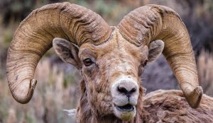
For travelers on U.S. Highway 26-287, which parallels the eastern flanks of the Winds, the tiny community of Dubois is home to three noteworthy destinations. A visit to the National Bighorn Sheep Center is the perfect prelude to a tour of the nearby Whiskey Basin Wildlife Habitat Management Area, a wintering ground for the largest population of bighorn sheep in the U.S. Sojourners can book a guided tour of Whiskey Basin through the interpretive center. Parties prioritizing the opportunity to witness the legendary head-butting duels of bighorn rams should schedule their visits from late November to mid-December.
COURTESY OF NATIONAL BIGHORN SHEEP CENTER
The National Museum of Military Vehicles, located 8.5 miles southeast of Dubois, houses the world’s largest private collection of military vehicles. This 160,000-square-foot facility currently focuses its interpretive efforts on American military history from World War II to Vietnam. However, according to collections owner and museum founder Dan Starks, “The vehicles are [simply] the bait to tell stories [and] put people in the shoes of the young Americans who served in these 20th-century wars.”
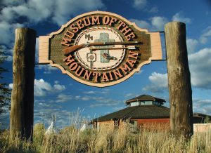
Museum of the Mountain Man
A tribute to the historic heart of Wyoming’s high country
In July 1835, trapper Osborne Russell observed “Thousands of mountain Sheep” in the Absaroka and Wind River mountains, which were “all very fat so that this could be called no other than high living [in terms of altitude] and rich provisions.” Like the Sheepeater (Tukudika) Shoshone and Mountain Crow (Apsáalooke), trappers were attracted by the area’s rich game populations and South Pass, a break in the Continental Divide that provided access to the Green River Valley and the Winds’ western slopes.
COURTESY OF THE MUSEUM OF THE MOUNTAINMAN
Consequently, six of the 16 rendezvous held annually during the mountain man era (1825 – 1840) convened at Horse Creek, near present-day Daniel, Wyoming. The Museum of the Mountain Man in Pinedale interprets this colorful period of American history. Visitors particularly interested in this topic should target the second weekend of July, when contemporary mountain men and living-history presenters renew the traditions of that bygone era during the Green River Rendezvous.
Douglas A. Schmittou is a freelance writer in Billings, Montana. His research focuses on travel in the Northern Rockies; evidence-based wellness protocols; and 19th century Plains Indian art, material culture, and ethnohistory. His work has appeared in Montana: The Magazine of Western History, Plains Anthropologist, and American Indian Quarterly.
No Comments